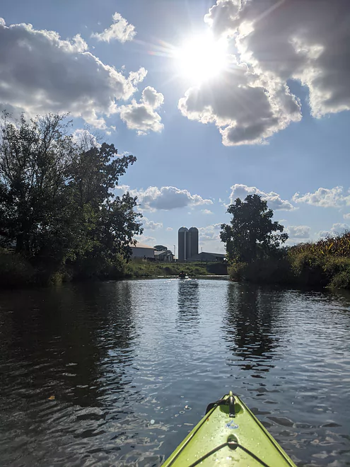
Sugar River – Paoli – Guest Review


Author:
Jodell Quamme
Date:
September 19th, 2021
Put-in:
Hwy 69 (Falk Wells boat launch)
Take-out:
Hwy A (south of Basco)
Distance:
7.7 Miles
Time:
5 hours with a long lunch break
Gradient:
3.5' per mile
Water Level:
Sugar River @ Verona 38 CFS or 2.87'
This section from 69 to Paoli was fun. Many riffles, one old dam that we ran with no problem, very few trees across the whole river. Ate and had a beer in Paoli. Live music, lots of fun going on there. The second section had many trees we needed to duck to get under. And one tree required us to get out and carefully pull our yaks over part of the log. It looked to be a recent addition to the river as it still had leaves on the branches. We really liked the paddle! A great day.
Thanks for the review Jodell!
WisconsinRiverTrips.com is always very appreciative of guest reviews, and if you the reader is ever interested in submitting one, you can use this online form.
Detailed Overview
- Upstream of Hwy PD: Likely too many logjams.
- Hwy PD to White Crossing Road: (0.4 miles) Mostly straight and likely channelized. Perhaps a few logjams. Could be a tight fit during low water.
- White Crossing Road to Valley Road: (4.9 miles)
- White Crossing Road to Bobcat Lane: (2.2 miles) Open, straight and channelized…this is a simple but pleasant paddle with frequent vistas of Epic Systems (at the edge of Verona). There are a few logjams here that can be hopped over in high water.
- Bobcat Lane to Valley Road: (2.7 miles) Slower, twistier and more wild than the upstream section, but less interesting. No noteworthy logjams.
- Valley Road to Riverside Road: (1.8 miles) There might be a logjam or two, as well as a problematic cattle fence.
- Note from Wade at Uppersugar.org: “The fence has been redesigned to be more paddling friendly. Both sections of the fencing now have a gap with vertically hanging PVC pipes that boats can pass through. It’s my understanding that this has worked well, but if you go down the river and have a different experience, please let me know.”
- Riverside Road to Hwy 69: (1.6 miles) There were fences and logjams here, but I think they have been cleared out.
- Hwy 69 to Hwy A: (7.7 miles)
- Hwy 69 to Paoli (Montrose Town Hall): (3.5 miles) Fantastic section.
- Paoli to Hwy A: (4.2 miles) Good section….but not as scenic as the previous leg.
- Hwy A to Belleville Park: (6.6 miles) Trip starts nice but becomes less interesting at the end by Belleville where the river is impounded by a dam.
- Belleville Park to Exeter Park: (4.8 miles) Nice paddle with scenic put-in and take-out. Highlights include a few sand and gravel bars and an attractive wooded section with good current.
- Exeter Park to Hwy X: (5.4 miles) A good prospect.
- Hwy X to Hwy C (Attica): (5.0 miles) A simple leg. There is nothing really scenic about it...but it's not a bad paddle.
- Hwy C to Hwy EE: (6.4 miles) A mediocre prospect. Maybe logjams.
- Hwy EE to Albany Boat Ramp: (2.5 miles) A weak prospect because of the lake paddling.
- Albany Boat Ramp to Decatur Albany Road: (2.9 miles) A weak prospect.
- Decatur Albany Road to Decatur Park: (4.5 miles) A weak prospect with some flowage paddling.
- Decatur Park to Hwy F: (2.2 miles) Good prospect.
- Hwy F to Clarence Bridge Park: (4.6 miles) Good prospect with an exposed rock outcrop.
- Clarence Bridge Park to Hwy T: (5.9 miles) A good prospect.
- Hwy T to W. Beloit Newark Road: (1.9 miles) A good prospect.
- W. Beloit Newark Road to Nelson Road Boat Ramp: (4.6 miles) Avon Bottoms Wildlife Area is probably nice but there might be some downed trees to negotiate.
- Nelson Road Boat Ramp to Haas Road: (6.6 miles) Good prospect.
- Haas Road to North Street: (4.1 miles) Good prospect.
- North Street to Harrison Road: (5.0 miles) Good prospect which ends at the Pecatonica River.
Trip Map
Overview Map
Photos Size:
How did your trip turn out? Questions or comments? Feel free to leave your feedback.
SUBMIT COMMENT!


